Showing 65 items matching north melbourne kangaroos
-
 Essendon Football Club
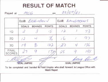
AFL scorecard, 22/07/2001
... North Melbourne Kangaroos... Essendon and North Melbourne Kangaroos at the MCG which Essendon... games ever. Essendon Football Club North Melbourne Kangaroos ...This is the scorecard for the home-and-away game between Essendon and North Melbourne Kangaroos at the MCG which Essendon won 27.9.171 to Kangaroos 25.9.159This item is of great significance for it is the official record of the greatest comeback in VFL/AFL history. Essendon came from 69 points down in the second quarter to defeat the Kangaroos by 12 points. It has been hailed as one of the greatest games ever.White cardboard card ruled into sectionsScores for each team for each quarter have been entered in blue ink and card has been signed by three umpiresessendon football club, north melbourne kangaroos, comebacks, significant events -
 City of Moorabbin Historical Society (Operating the Box Cottage Museum)
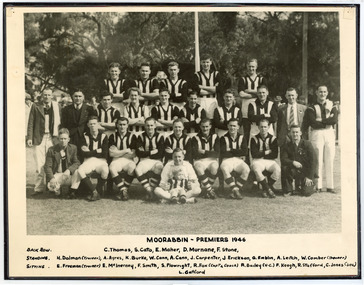
Photograph - Black & White Moorabbin Football Club Premiers 1946, c1946
Moorabbin played initially in the Federal Football League, making their debut in 1909 and competing until 1950. The club wore a black and white jumper like Collingwood. During this time the club won 12 premierships, including winning all six premierships staged over the nine years between 1940 and 1948 (the competition was in recess from 1942 until 1944) Moorabbin had a comparatively brief but quite successful stint in the Victorian Football Association between 1951 and 1963. The club won premierships in 1957 and 1963, and managed a highly impressive overall success rate of 62.5%. However, there was a sensational aftermath to the 1963 flag as Moorabbin fell foul of the VFA after agreeing to sell its ground to VFL club St Kilda. After a bitter wrangle the eventual upshot was that the Moorabbin committee voted 19-2 to disaffiliate from the Association. Before joining the VFA Moorabbin had spent four highly successful decades as a member of the Federal Football League and its precursor the Federal Football Association. During its debut season in the VFA the club played its home matches at Cheltenham, but the development of a new ground in Moorabbin had been a condition of entry. By 1952 that new ground, Moorabbin Oval, was ready, and over the ensuing eleven seasons it would become one of the most difficult grounds in the VFA for visiting teams to win at. Prior to entering the VFA Moorabbin enjoyed premiership success in the Federal Football League on a dozen occasions, including four times in succession between 1945 and 1948.. The Moorabbin name is now used by the Moorabbin Kangaroos Football Club in the Southern Football League. The club was originally known as Moorabbin West Football Club, taking on the new name from 2003. Moorabbin Football Club was established 1909 and was very successful playing in the Federal Football League, Victorian Football Association. Sadly was removed from the Linton St. Oval 1963, after winning the Premiership, by Moorabbin City Council and St Kilda VFL team took over.Black & White photograph showing Moorabbin Football Club 1946 Premiership in Federal Football LeagueMOORABBIN - PREMIERS 1946 / Back Row C.Thomas, S.Cato, D.Murnane, F.Stone, / Standing - H.Dolman (trainer), A.Ayers, K.Burke, W.Cann, A.Cann,J.Carpenter, J.Carpenter, J.Erickson, G.Emblin, A.Leitch, W.Comber (trainer) / Sitting - E.Freeman (trainer) E.MxInerney, F.Smith,S.Plowright, R.Fox (Captain Coach) R.Bailey (vice.Captain)F.Keogh, R.Stafford, C.Jones (Secretary)moorabbin football club, victorian football association, victorian football league, moorabbin kangaroos football club, st kilda football club, linton oval moorabbin, north melbourne football club, smith j l, smith mary ann, stanley helen, chaff cutter, horse drawn carts, toll gates brighton, motor cars 1900, steam engines, early settlers, bentleigh, parish of moorabbin, city of moorabbin, county of bourke, moorabbin roads board, shire of moorabbin, henry dendy's special survey 1841, were j.b., bent thomas, o'shannassy john, king richard, charman stephen, highett william, ormond francis, maynard dennis, market gardeners, vineyards, orchards, sport -
 Greensborough Historical Society
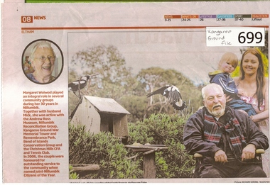
Newspaper clipping, Diamond Valley Leader, A Life Worth Celebrating, 12/09/2012
The item was written about Margaret Woiwod who passed away on August 1 2012.Margaret Woiwod was a prominent community minded person who lived in Bend of Isles for 25 years and later in Eltham North.A multi coloured 1 page newspaper article.Nilbend of isles, kangaroo ground fire tower, nillumbik reconciliation group, woiwod -
 Greensborough Historical Society
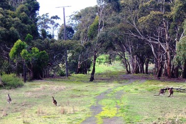
Photograph - Digital image, Marilyn Smith, Blue Lake: Kangaroos at Yellow Gum Park, 19/06/2015
Blue Lake is in Yellow Gum Park in the Plenty Gorge, north of Greensborough. These photos show kangaroos in the Park.Digital copy of colour photographsyellow gum park, blue lake, plenty gorge park -
 Ringwood and District Historical Society
Voters Rolls, Mail Print, Borough of Ringwood Voters Rolls - 1925 to 1951, 1925 to 1951
Voter's Rolls for the Borough of Ringwood - Southern Province, including subdivisions of Ringwood, Croydon and Kangaroo Ground. Also electoral districts of Nunawading, Evelyn and Upper Yarra.Voters Rolls - paper covered.; 1. 1925 to 1928 - 4 copies; 2. 1932 to 1939 - 9 copies; 3. 1940 to 1949 - 14 copies; 4. 1950 to 1951 - 2 copiesBorough of Ringwood - Voters Roll -
Ringwood and District Historical Society
Badge, V.A.Y.C. Ringwood (Victorian Association of Youth Clubs)
Badge, circular, diameter 2.1cm, with blue and white enamel markings. In the centre is a kangaroo shape in brass, above V.A.Y.C Ringwood. There is a pin-clip fastener on the back of the badge. +Additional Keywords: Victorian Association of Youth ClubsV.A.Y.C. Ringwood (Victorian Association of Youth Clubs) -
 Ringwood and District Historical Society
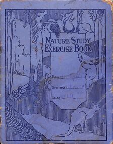
Work on paper, Nature Study Exercise Grade v111 name Wilson on the back c. 1930s (Part of the Wieland collection)
Ruby Wilson was related to the Wieland family through the marriage of her sister Amy Ellen Thelma to Stanley Wieland.Blue covered book with black stenciled picture of gum tree , koala , kangaroo and kookaburras.All pages filled with hand writing and drawn pictures In ink on back the name Wilson. -
 Ringwood and District Historical Society
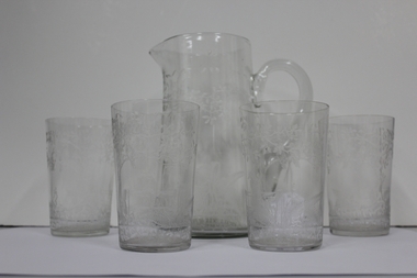
Domestic object - Jug and Glasses, Vintage glasses and pitcher set
Jug and four glasses, each item with hand etchings of Australian fauna and flora - kookaburra sitting on a post and rail fence; kangaroos; and tree ferns:; 1. Glass Jug with handle and spout.; 2-5. Glasses +Additional Keywords: O'Connor, Neville / O'Connor, Ian -
 Ringwood and District Historical Society
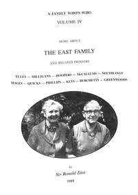
Book, More About The East Family, 1988
Hard cover book - Full title: A Family Who's Who Volume IV - More About The East Family And Related Pioneers - Yules, Milligans, Hoopers, McCallums, Neethlings, Males, Quicks, Phillips, Keys, Burchetts, Greenwoods.Inside back cover - "On Sunday 13th November, 1836, Samuel East, a Methodist local preacher, conducted at Kingscote on Kangaroo Island, the first church service held in South Australia. See page 35 of A South Australian Colonist of 1836." "This is to certify that Sir Ronald East took part in South Australia's 150th Anniversary Celebrations in 1986 by participating in Uniting Church Service 9.11.86 as descendants of Samuel East (signed) Kym Boynton, Jubilee 150 Board Chairman." -
 Eltham District Historical Society Inc
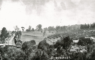
Photograph, Tom Prior, Research
Taken north along Ingrams Road after turning the bend, the area was known for its orchards.The Reynolds family were early settlers in Research. The Reynolds/ Prior collection of photographs were taken by Tom Prior, the maternal uncle of Ivy Reynolds, around 1900 and the 60 photos in the album give a fine overview of many of the landmarks of Research and Eltham over 100 years ago. lvy lived in the family home for many years at 106 Thompson Cres Research. Ivy's father, Ernst Richard Reynolds and grandfather, Richard Reynolds, lived at the same address. Ivy's father Richard worked for Mr. Trail on his property in Research. Reynolds Road is named after the family. Mr Tom Prior (wife Eva) worked at the Melbourne zoo. He was very innovative and made his own camera, using the black cloth hood to exclude the light. The photographs are a reminder of the rural nature of Research and Eltham and its rich heritage. Black and white photograph mounted in an album, the Reynolds/Prior Photograph Collection, this being one of 53 reproduced black and white images of early Eltham.The Reynolds/Prior Photograph Collection, Presented to the Eltham District Historical Society, 14 June 2006 by Ross McDonald. A second copy was also presented to the Andrew Ross Museum, Kangaroo Groundingrams road, orchards, research (vic.), reynolds prior collection -
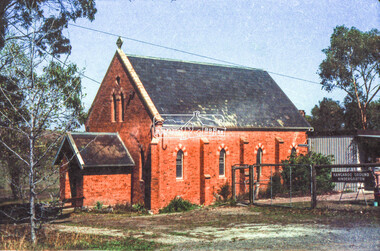 Eltham District Historical Society Inc
Negative - Photograph, Russell Yeoman, Kangaroo Ground Presbyterian Church, c.1980
View from front north side looking south west from cnr of Graham Road and Eltham-Yarra Glen RoadRoll of 35mm colour negative film, 2 strips Kodak Safety 5035 Colour print (x1)Kodak Safety 5035kangaroo ground, church, presbyterian church -
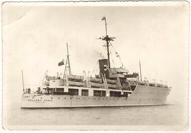 Sunshine and District Historical Society Incorporated
Photograph (1950), The Migrant Ship HELLENIC PRINCE, Copy 27/01/2014 - (Original Post Card circa 1950)
In 1949 the HELLENIC PRINCE with its 3 hospitals, 2 cinemas, and air conditioned accommodation was chartered by the International Refugee Organisation to transport displaced persons from Europe to Australia. Its first trip was to Sydney where it arrived with 1000 passengers on 5 December 1949. On the third trip it left Naples on 23 March 1950, and arrived in Fremantle on 20 April 1950, and in Melbourne on 25 April 1950. The men and women were separated for the voyage with my father sleeping on a hammock in a large room with other men, while my mother, my brother, and I had bunks in a shared cabin. On board were displaced persons ex Bagnoli Camp Italy, some of whom later built their bungalows on the grassy and rocky paddocks near Sunshine Victoria, and began to establish a new life in a new country. A few of the families that arrived on the third trip and purchased land in the Dunkeld Ave - Sandford Ave area of North Sunshine (Birmingham Estate) were Janczak, Kolanowicz, Mroz, Pawlak, Rasztabiga, Skrobalak, Szydlowski, Witkowski, and Zielinski. Some friends settled elsewhere in Sunshine. The family Tabaka went to West Sunshine just over the Derby Rd Bridge, while the family Wojcik went to Ardeer. The ship first started service in 1929 for the Royal Australian Navy as the HMAS ALBATROSS. It had a standard displacement of 4,800 tons and was 443 feet 7 inches (135.2 metres) long, and its top speed during trials reached 22 knots (41 km/hr). It was built at Cockatoo Island Dockyard as Australia's first Aircraft Carrier (seaplanes), but the aircraft that it was designed for were retired just before the ship went into service. A new plane specifically designed to work with the Albatross began operations after the ship was decommissioned in 1933, and placed into reserve in Sydney Harbour. Seaplanes continued to operate from the anchored ship. (Click on the Link 'HMAS Albatross (1)' situated above the Object Registration number to view pictures of the HMAS Albatross on the Navy web site). In 1938 the ship was recommissioned and transferred to the Royal Navy as part payment for the light cruiser Hobart. The ship then did military service for the Royal Navy during World War 2. It did patrol and escort duties in the southern Atlantic, and from mid 1942 in the Indian Ocean. By early 1944 the ship was converted so that it could repair landing craft and other support vessels off Sword and Juno beaches. The ship managed to return 132 craft into service and to save 79 others from total loss. On 11 August 1944 Albatross was torpedoed with the loss of either 50 or 66 personnel, but was able to be towed back to Portsmouth. After repairs she did a short service as a minesweeper depot ship, and following that was placed into reserve on 3 August 1945. In August 1946 the ship was sold for commercial use but the plans to convert it into a luxury liner or a floating cabaret fell through. The ship was again sold on 14 November 1948 to the British-Greek Yannoulatos Group, who renamed it HELLENIC PRINCE in recognition of the birth of Prince Charles and his Greek heritage. After conversion into a passenger ship the Hellenic Prince made several trips to Australia transporting displaced persons, however apparently not all trips were pleasant for the passengers. In the on board newsletter 'Kangaroo' dated 5 January 1951, the ship's master P. C. King expressed his indignation about the behaviour of passengers and made accusations of mutiny. According to some immigrants the conditions were appalling and overcrowded with 1200 passengers. Passengers were supposedly required to work and were paid with Woodbine cigarettes. The drinking water ran out, the freezer broke down, and fresh food that was brought on board went to the crew. Sea sickness was rife because the ship was rarely level due to malfunctioning pumps. (The newsletter 'Kangaroo' can be viewed at the Museum Victoria web site by clicking the Link 'Newsletter - Kangaroo'). In 1953 during the Mau Mau uprising the Hellenic Prince was used to transport troops to Kenya, and in 1954 the ship came to an end in a scrap yard at Hong Kong. THE ABOVE INFORMATION WAS COMPILED FROM; (1) http://en.wikipedia.org/wiki/HMAS_Albatross_(1928) (accessed 11/2/2013), (2) An article by Graeme Andrews found at http://www.afloat.com.au/afloat-magazine/2011/july-2011/The_boat_people_of_the _forties_and_fifties#.UuYY6ou4apo (accessed 27/1/14), (3) http://museumvictoria.com.au/collections/items/273166/newsletter-kangaroo-hellenic-prince-5-jan-1951 (accessed 27/1/14), (4) National Archive search starting at; www.naa.gov.au/collection/search/index.aspx (accessed 27/1/14), (5) http://www.flickr.com/photos/41311545@N05/3864781978 (accessed 29/1/14). Hellenic Prince has a significance to Sunshine Victoria because some of the displaced people from Europe, who arrived in Melbourne on Anzac Day 1950, were among the first people to settle in the grassy and rocky paddock areas of North Sunshine. These settlers established a residential suburban area out of the paddocks. In those early days there were no services and the planned roads were basically just drawings on a map. The ship is also significant because it was named in recognition of the birth of Prince Charles. In the ship's former life as the HMAS Albatross the significance is that it was built in Australia as our country's first Aircraft Carrier (seaplanes).New photograph made from a scanned copy of a circa 1950 Post Card featuring the ship on calm water.Hellenic Prince / Hong Konghellenic prince, migrant ship, displaced persons, refugees, international refugee organisation, bagnoli camp, hmas albatross, yannoulatos group -
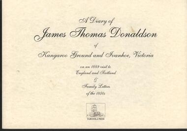 Nillumbik Historical Society Incorporated
Book - Softcover book, Tarcoola Press, A Diary of James Thomas Donaldson of Kangaroo Ground and Ivanhoe Victoria, 1998
on an 1889 visit to England and Scotland & Family Letters of the 1850'sCover is parchment coloured card 300gsm with white paper pages 100gsm - 50 pagesnon-fictionon an 1889 visit to England and Scotland & Family Letters of the 1850'sdonaldson james t 1832-1916, great britain - description & travel, kangaroo ground, heidelberg -
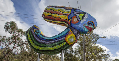 Nillumbik Shire Council
Public Art: Deborah HALPERN, 'Queen of the Shire'; Location: Cnr Kangaroo Ground-Warrandyte Rd & Research-Warrandyte Rd, North Warrandyte, 2015
Deborah Halpern was raised in Nth Warrandyte. Her connection to the area and the significant contribution that she and her family (founding members of Potters Cottage) have made to the artistic heritage and culture of the Shire is acknowledge with the commission of this piece. Deborah Halpern is a highly recognised and respected local artist with an acclaimed national reputation in the arts community. This work is a gateway piece, welcoming residents and visitors into the Shire from the southern end of the boundary. 'Queen of the Shire' reflects the creative spirit that flows endlessly in the Shire, inspired by the landscape. This work forms part of a series of sculptures that Halpern has created along the banks of the Yarra in Melbourne ('Angel' - Birrarung Marr and 'Ophelia' - Southgate). This sculpture is an excellent example of Halpern’s ouvere and 'tile construction' technique for which she is renowned. Materials: coloured glass tiles, fibreglass, aluminium, steel. A sweeping stylised (female) form covered in bright and colourful tiles held aloft by two steel poles. queen, sculpture, semi-abstract, stylised, glass, tiles, public art, halpern, ek prac 2015 -
 Eltham District Historical Society Inc
Photograph - Digital Photograph, Alan King, Kangaroo Ground General Store, Eltham-Yarra Glen Road, 28 December 2007
The present store was built circa 1900 to replace another which had been destroyed by fire in 1898, which had replaced a predecessor on the opposite side of the road in 1865. The store was also used as a post office until early 2000s. The general store is historically significant because it has a long association with Kangaroo Ground and has been an important centre of community life for more than 120 years - Council meetings used to be conducted in the front room of the store at a time when Kangaroo Ground rivalled Eltham as the major centre of the Shire. The general store is historically and aesthetically significant as one of a group of three well preserved public buildings in the Kangaroo Ground hamlet and as a major heritage component of Kangaroo Ground which was one of the earliest settled areas of the Shire and which has the character of an English village rather than an Australian settlement. Covered under Heritage Overlay, Nillumbik Planning Scheme. Published: Nillumbik Now and Then / Marguerite Marshall 2008; photographs Alan King with Marguerite Marshall.; p77This collection of almost 130 photos about places and people within the Shire of Nillumbik, an urban and rural municipality in Melbourne's north, contributes to an understanding of the history of the Shire. Published in 2008 immediately prior to the Black Saturday bushfires of February 7, 2009, it documents sites that were impacted, and in some cases destroyed by the fires. It includes photographs taken especially for the publication, creating a unique time capsule representing the Shire in the early 21st century. It remains the most recent comprehenesive publication devoted to the Shire's history connecting local residents to the past. nillumbik now and then (marshall-king) collection, eltham-yarra glen road, kangaroo ground general store -
 Eltham District Historical Society Inc
Photograph - Digital Photograph, Alan King, Wellers Restaurant, 150 Eltham-Yarra Glen Road, Kangaroo Ground, 23 January 2008
Originally Wellers Hotel, it was constructed by Edward Weller in 1872. Following his death in 1883 it was taken over by his widow, Mary Weller. The hotel was delicensed in 1909 and converted to a private residence. Around 1920 William Pitman bought the property, succeeded by his son Vernon who coined the term Pittman's Corner. Vernon and Isabel Pitman owned the house form 1945-1973. Following Vernon's death, Isabel remained there till her death in 1983. The property was converted to a restaurant in 1984 by owners Robert and Kath Hendry who undertook extensive renovations in 1988. Shawn and Stephanie Wolfe purchased the property from the Hendrys in 2003 and introduced live entertainment with many famous bands and entertainers from the 1960s, 1970s and 1980s performing there, including James Reyne, Daryl Barithwaite, Brian Cadd and Billy Thorpe. In 2014 the Wolfe's sold the property and the entire contents were sold at auction. New (local ) owners Gregory Anderson, Craig Jones and Steve Gist refurbished the property and relaunched it as Fondata 1872 in 2017. Covered under Heritage Overlay, Nillumbik Planning Scheme. Published: Nillumbik Now and Then / Marguerite Marshall 2008; photographs Alan King with Marguerite Marshall.; p87This collection of almost 130 photos about places and people within the Shire of Nillumbik, an urban and rural municipality in Melbourne's north, contributes to an understanding of the history of the Shire. Published in 2008 immediately prior to the Black Saturday bushfires of February 7, 2009, it documents sites that were impacted, and in some cases destroyed by the fires. It includes photographs taken especially for the publication, creating a unique time capsule representing the Shire in the early 21st century. It remains the most recent comprehenesive publication devoted to the Shire's history connecting local residents to the past. nillumbik now and then (marshall-king) collection, eltham-yarra glen road, fondata 1872, kangaroo ground, wellers restaurant, billy thorpe, brian cadd, craig jones, daryl barithwaite, edward weller, gregory anderson, hotels, james reyne, kath hendry, mary weller, restaurants, robert hendry, shawn wolfe, stephanie wolfe, steve gist -
 Eltham District Historical Society Inc
Certificate, Shire of Eltham: Presented to Pte. George Melville Balfour, VX6104, 1 August 1942
Certificate of appreciation presented to Private George Melville Balfour, VX6104, for voluntary enlistment for active service overseas. Prior to the war, George Balfour lived at Wangakeirra(?), Kangaroo Ground. Post war, he lived at Lavender Park, Eltham. He served in the 2/8 Batallion, AIF, in North Africa and taken prisoner of war in Greece. In the UK post May 1945 and in Australia December 1949. Never married.Colour photocopy 33 x 24 cm of a certificate 2/8 battallion, aif, certiificate, cr. a. brinkkotter, cr. price, eltham, george melville balfour, lavender park, prisoner of war, second word war, shire of eltham, vx6104 -
 Eltham District Historical Society Inc
Film - Video (VHS), IMP Productions, The Shire of Etham - The Evergreen Shire (Series 69, Item 4), c.1985
Shire of Eltham Archives: Series 69, Item 4 This video was produced for the Shire of Eltham by IMP Productions and provides a description of the shire, 277 square km on a north/northeast axis, some 25 km northeast of the centre of Melbourne with a population of around 40,000. Scenes include Yarra River, rural settings and urban settings, housing estates, Shillinglaw Cottage, Pigeon Bank at Kangaroo Ground, the Eltham Railway Trestle Bridge with reference to the fight by locals in the 1970s to save it from replacement, Montsalvat, mudbrick making and its use as a building material, the use of mudbrick in the Eltham Community Centre blending harmoniously with the environment. Emphasises people living in the area due to the qualities of life provided. Also the Living and Learning Centre, St Andrews Markets and other local markets, the Eltham Leisure Centre, cricket and horse riding at Eltham Lower Park, the Infant Welfare Centre (part of the Eltham War Memorial), how residents are mindful of protecting their historical heritage, the CBA bank and Allwood House at Hurstbridge, Tracey Naughton about the Eltham "As we are" Community Banner project and the “River of Life banner”, the Parks and Gardens office in the former Police Residence building (now the Local History Centre), Alistair Knox Park, road planning and types of roads, tree canopy, Peck's Dam, green carparks, road drainage, Gordon Ford's garden and natural landscapes, and Were Street shops in Montmorency. Planning for shopping facilities and carparks with a population of 40,000 growing to 55,000, Arthur Street Mall and carpark, local village feel in the shopping centre. Councillors and Council staff featured include Mary Grant, Bob Manuell, Rodney Roschellor, John Cohen, Alan Baker. Also scenes of Commercial Place, Diamond Valley Railway, Eltham Galley, Riverclay and canoeing on the Yarra intermingled with images of the shire from the Shire of Eltham Pioneers Photograph collection.VHS Video cassette Converted to MP4 file format 00:11:56; 79MBshire of eltham, video recording, shire of eltham archives, alistair knox park, allwood house, arthur street, arthur street mall, bob manuell, canoeing, carparks, cba bank, commercial place, council staff, councillors, cr. mary grant, cricket, diamond valley railway, eltham community banner project, eltham community centre, eltham galley, eltham leisure centre, eltham living and learning centre, eltham lower park, eltham railway trestle bridge, eltham war memorial, gordon ford garden, horse riding, housing estates, hurstbridge, infant welfare centre, john cohen, kangaroo ground, local history centre, montmorency, montsalvat, mudbrick, parks and gardens, peck's dam, pigeon bank, police residence, river of life banner, riverclay, road drainage, road planning, rodney roschellor, shillinglaw cottage, shire of eltham pioneers photograph collection, st andrews market, tracey naughton, tree canopy, were street, yarra river, alan baker -
 Eltham District Historical Society Inc
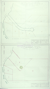
Slide - Photograph, Eltham Shire Council, Tentative Plan of Subdivision, Part of Crown Allotment 20A and Part 20B, Parish of Nillumbik, County of Evelyn, 1969
35mm colour positive transparency blue Agfacolour Service plastic mountE2, N899, Young subdivision, Kangaroo Ground-Warrandyte Road, North Warrandyte, 4 August 1969infrastructure, map, planning, subdivison lots, kangaroo ground-warrandyte road, north warrandyte -
 Eltham District Historical Society Inc
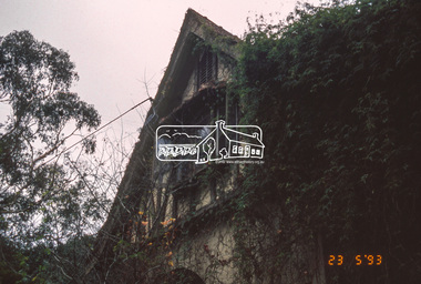
Slide - Photograph, The Robins. Kangaroo Ground-Warrandyte Road, North Warrandyte, 23 May 1993
The 1993 Eltham Heritage Tour was enjoyed by a busload of members of the Historical Society on a fine, calm day, Sunday May 23rd. Between 10.00 am and 4.30 pm, except for a brief lunch stop at the Eltham Living and Learning Centre, members passed about thirty places of local interest and others recommended for the Historic Buildings Register and the Register of the National Estate. A number of significant trees and buildings were also highlighted along with the opportunity to explored some of the properties.35mm colour positive transparency (1 of 24) Mount - Kodak Kodachromeactivities, kangaroo ground-warrandyte road, north warrandyte, shire of eltham historical society, the robins, heritage excursion -
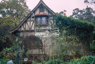 Eltham District Historical Society Inc
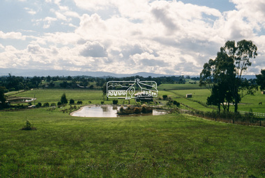
Slide - Photograph, Kangaroo Ground, possibly looking north from Henley Road, c.May 1988
35mm colour positive transparency (1 of 25) Mount - Kodak EktachromeProcess Date MAY 88Mhenley road, kangaroo ground -
 Eltham District Historical Society Inc
Photograph - Black and White Print, Old settler's cottage, Floods Lane, North Warrandyte, c.1935
An early settler's cottage of 1920s vintage near Floods Rd taken in the 1930s. Was originally Floods Lane and became Floods Road off Kangaroo Ground-Warrandyte Rd near boundary of North WarrandyteInscribed in pencil on reverse "early 20's near Flood Rd taken 30's. 21/1.89" and in pen ".16/1.80"cottage, floods lane, floods road, houses, kangaroo ground-warrandyte road, north warrandyte, pioneers -
 Eltham District Historical Society Inc
Calendar, Nillumbik Community Calendar 1996: Nillumbik The Places and the People, 1995
Community Project. One of a series of calendars which the Shire of Eltham and the Shire of Nillumbik published annually Photography by Graham Hosking Photography. Monthly calendar printed in landscape mode, with feature photograph and template of dates for each of the 12 months presented. Includes advertisements. Back of the calendar includes a list of emergency numbers.calendar,1996,shire of nillumbik,research primary school,eltham north adventure playground,edendale gateway,tony trembath,eltham leisure centre,diamond valley railway,kangaroo ground pony club,eltham community and reception centre,eltham community centre,shire of nillumbik,swimming pool,yarra river,, diamond creek trail,yarrambat golf course,sugar loaf reservoir,map -
 Eltham District Historical Society Inc
Slide, Maroondah Aqueduct, Research, Victoria, 22 Mar. 1981
An inspection tour of the Maroondah Aqueduct was undertaken by the Shire of Eltham Historical Society on Sunday, March 22nd, 1981, commening where the aqueduct crosses Main Rd., Research, just below Eltham College. The Maroondah Aqueduct was part of Melbourne’s water supply system. It carried water over the 66 km from the Maroondah Reservoir on the Watts River at Healesville to the Preston Reservoir. Of this length, 41 km were open channel, 10 km, tunnel through hills and 15 km in 14 inverted siphons across stream valleys. The route of the aqueduct is north of Tarrawarra and Yarra Glen, along the Yarra escarpment south of Christmas Hills and crossing Watsons Creek into the present Shire of Eltham near Henley Rd. The eastern part of the route lies entirely within the former boundaries of the shire. The aqueduct passes south of Kangaroo Ground to Research and crosses the Diamond Creek by siphon at Allendale Rd., Eltham North. It then extends to Reservoir via St. Helena, Greensborough North and Bundoora. Water first flowed through the aqueduct in February 1891 when it was fed by a diversion weir on the Watts River. Records of the building of the aqueduct indicate that it was a significant construction achievement. The present Maroondah Reservoir was completed in 1927 and the aqueduct was enlarged at that time to take increased flows. About 1971 the section of the aqueduct through and north of Research was replaced by a large pipe and that section of the channel is now unused. The channel has remained largely intact (unlike sections at Greensborough and Bundoora where long lengths of the disused aqueduct have been demolished or filled in). The M.M.B.W. relinquished control of the disused aqueduct reserve which is crown land and the Shire of Eltham took control of this section of the reserve as a linear park. The Maroondah Aqueduct is considered to be an important historic structure, not just to the local area but to the metropolitan area generally. It is considered important to preserve substantially intact long lengths of the disused aqueduct, together with its bridges and other associated structures. 35 mm colour positive transparency (1 of 5) Mount - Agfachrome Agfa CS System black 8 dotsactivities, heritage excursion, maroondah aqueduct, research (vic.), shire of eltham historical society -
 Eltham District Historical Society Inc
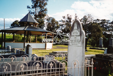
Photograph, A walk through the cemetery at Kangaroo Ground, Diana Bassett-Smith, 1 October 2001, 2001
The Kangaroo Ground Cemetery celebrated its 150th anniversary in 2001. Celebrations included the opening of a new rotunda on the 26 October 2001. Ths photo is a part of a brief collection of reminiscences by Diana Bassett-Smith of locals who are buried at Kangaroo Ground Cemetery along with 17 photographs following a visit on 1 October 2001. "One other headstone, that of James Wilson. It was a Wilson who had a nursery at the North Eastern end of Bourchiers Road on the land known as Tintagell alongside the Yarra. He grew trees, pines in particular, and supplied within the district and to the gardens of Melbourne. According to Jimmy Cook. The last of the warriors is between the gate and the river. And confirmed by Dorrie Bourchier that the original pines to what is now our property came from Wilson. The only one left now is by Passiona. Lightening claimed the one at the corner of our drive." Colour photograph printkangaroo ground cemetery, rotunda, james wilson